72 Avenue Improvements & Extensions
Learn about the City's plans for 72 Avenue including the proposed road extension from 152 Street to Highway 15.
The City plans to make 72 Avenue a continuous east-west route from 144 Street to 196 Street. We also plan to widen certain segments along 72 Avenue.
This will come in multiple phases:
- 144 Street to 152 Street in Newton (includes road widening to add more vehicle lanes and multi-use paths for cycling and walking)
- 188 Street to 196 Street in Clayton (includes road widening to add more vehicle lanes, sidewalks and paths for cycling)
- 152 Street to Highway 15 (Proposed. Includes a new road extension with four vehicle lanes and shoulders on both sides)
Project open houses
We hosted open houses in September 2024. View the information boards from the open house.
Map of projects
See the upcoming, future, and proposed projects along the 72 Avenue corridor:

Project benefits
These projects will help achieve the following goals:
- Improve traffic flow and reduce congestion and travel times along 72 Avenue and on parallel routes including Highway 10, 64 Avenue, and 88 Avenue. Traffic modelling shows that by 2050, traffic will increase by 36 to 56% on east-west roads if 72 Avenue isn't extended from 152 Street to Highway 15.
- Increase connectivity with a direct east-west route to better connect people and goods movement across the city and the region. 72 Avenue connects the communities of Newton, Fleetwood, Cloverdale and Clayton. It also connects Surrey residents to Delta, Langley and beyond through regional highway connections.
- Support city growth as Surrey’s population is projected to reach one million people as early as 2042. In May 2023, Council identified and prioritized developing specific arterial roads to support the city's growth. The 72 Avenue corridor was prioritized including extending the road from 152 Street to Highway 15.
72 Avenue project details
144 St to 152 St road widening
Currently, 72 Avenue is 4 lanes from 120 Street to 144 Street with no on-street parking.
The 144 Street to 152 Street Improvements project will include the following improvements:
- Widening the road from 2 to 4 travel lanes to reduce congestion and prepare for future growth
- Adding multi-use paths for walking and cycling
- Potential new traffic signal at 146 Street to improve access and safety
- Upgrading transit stops with bus shelters to increase safety and access to transit
It will be necessary to remove the on-street parking to make room for the additional vehicle lanes and multi-use paths for cycling and walking.
Project construction anticipated to begin in 2026.
152 St to Hwy 15 road extension (proposed)
In March 2024, Council directed the City to proceed with detail designs for the extension of 72 Avenue between 152 Street and Hwy 15.
Although this area is within the Agriculture Reserve Area (ALR), there is a 20-metre-wide unopen road allowance that exists through the 5 km area between 152 Street and Hwy 15. This road allowance was established in 1875 for the purposes of this road corridor.
The City developed various road design options to determine a plan that best balanced the adjacent agriculture land uses and various transportation needs of the community including drivers, trucks/goods movements, transit riders, pedestrians and cyclists.
Council directed the City to proceed with a four lane road which includes:
- two travel lanes in each direction to meet Surrey’s future transportation needs and improve access to agricultural land
- improved agricultural ditches and full movement access to farm properties
- wide road shoulders for larger farm vehicles and confident cyclists
- full movement intersections at 152 Street, 168 Street, and Hwy 15
- bridge across Bear Creek and Serpentine River to reduce environmental impacts
The road design will look similar to 176 Street, near 8 Avenue, as illustrated in the graphic.
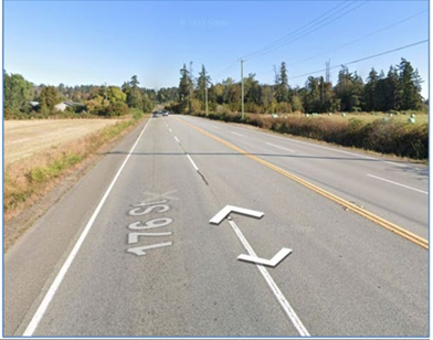
This design strives to achieve an overall balance for Surrey residents, businesses and farmers.
Cycling and walking
The City carefully considers each road corridor and the competing interests for road spaces when developing a road design, while minimizing project costs.
The proposed extension of 72 Avenue does not include multi-use paths for cycling and walking for several reasons:
- Local farmers expressed concerns that multi-use paths would hinder farm vehicle movement and access to nearby farms, as these paths require curbs that create physical barriers.
- The project costs would increase by $20 million.
- The City is adding cycling lanes and sidewalks on parallel east-west roads such as 64 Avenue. Additionally, the Province is investing $40-60 million along Fraser Highway as part of the Surrey Langley SkyTrain project which will provide an adjacent east-west protected cycling corridor.
Transit
72 Avenue between 120 Street to 152 Street is part of TransLink’s Major Route Network (MRN), providing frequent transit service and a regional truck route. The City anticipates 152 St to Hwy 15 to be included in the MRN as a designated truck route. The segment from Hwy 15 to 196 St is not anticipated to be a truck route.
Protecting the environment
The City did an environmental assessment to ensure potential project effects are understood and addressed. The City will also obtain regulatory permits and incorporate best management practices during construction.
Mitigating impacts to watercourses
The environmental assessment identified a number of salmon bearing watercourses including Bear Creek, Fleetwood Creek, the Serpentine River and some un-named ditches.
To minimize impacts to the creeks, the road corridor design will include:
- bridges across Bear Creek and Serpentine River
- large box culverts across Fleetwood Creek and 168 Street canal with the potential for fish and wildlife passage features.
Mitigating impacts to wildlife
- The study also identified the Barn Owl as a species at risk with critical habitat near the project corridor, specifically east of the Serpentine River where the presence of suitable habitats, such as barns, exist. The 72 Avenue project is not anticipated to impact Barn Owl nesting habitat.
- There is also one bald eagle nest located within the 72 Avenue corridor alignment which may be impacted requiring relocation when the nest is inactive to either an adjacent tree or artificial nesting platform.
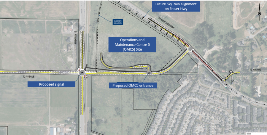
Hwy 15 to Fraser Hwy road extension (future)
The City plans to extend 72 Ave from Hwy 15 to Fraser Hwy as illustrated in image.
The Province plans to build a SkyTrain Operations and Maintenance Centre 5 (OMC5) at 17916 Fraser Highway. This will be the fifth OMC location for SkyTrain’s main network of the Expo and Millennium lines operated by TransLink subsidiary BC Rapid Transit Company (BCRTC).
The City is in discussions with the Province regarding the integration and timing of delivering 72 Avenue corridor between Hwy 15 and Fraser Highway.
Fraser Hwy to 184 St road extension
The City is connecting 72 Avenue to Fraser Highway as shown in image.
As part of this project, intersection improvements at 72 Avenue and 184 Street including new left turn lanes will be added to improve access and traffic flow.
This project is currently under construction with completion planned this fall.
This segment of 72 Avenue will remain 2 lanes until future development provides the necessary land to widen the road to 4 lanes.

180 St to 188 St road widening (future)
Future project - development dependent
The timing of the road improvements between 180 Street and 188 Street will depend on private development activity as the City will need to secure additional land through the development process in order to widen the existing road corridor to four lanes.
188 St to 196 St road widening
The City plans to widen the road from 2 to 4 travel lanes with sidewalks and paths for cycling on both sides of the road.
Project construction is anticipated to begin 2025.
Parking
On-street parking along this stretch of 72 Avenue was temporary as the existing parking signs indicate. Project will require removal of some on-street parking to make room for the additional vehicle lanes, sidewalks and cycling facilities on both sides.
The City recognizes the high demand for parking in the area and will establish parking wherever feasible along this segment. The City will also add on-street parking pockets on other streets to mitigate the loss of on-street parking along 72 Ave.
On-street parking will be maintained on both sides from 188 St to 189 St, and on the south side between 190 St to 191 St and 192 St to 194 St.
The City will create additional parking spaces on side streets along 189 St, 190 St, 191 St, 193 St, 194A St and 195 St and 196 St.
Resources:
- Corporate Report on approvals for 72 Avenue projects including 144 St to 152 St Road Widening, 152 St to Highway 15 Road Extension, and 188 St to 196 St Road Widening.
- Public Engagement Report
- Corporate Report on design contract award for 152 Street to Highway 15 Road Extension
- Corporate Report on 152 Street to Highway 15 Road Extension feasibility study.